|
|
|
|
|
| Climb > |
|
Mountain photos - amateur
and professional photos of mountains.
|
Author: Anatoly Dzhuly, Moscow
Kashkar
peak, 6435 m, ascent Route description 1st day, 11.07 R0.
R1.
1st day, 11.07, 2nd day, 12.07 R2. Snow-ice flank of the ridge with
rocky sites. Steepness up to 40 degrees, friable snow, unreliable belay,
so we fixed the rope and made 15,5 pitches (approximately 700 meters
up to the top), organized them on ice-axes and ice-screws (approximately
half-to-half)
Cornice across the ridge, descent
to the right - downwards on the western ridge of 5550 m peak and further
rappelling to the south through the cornice (only 2,5 pitches, 120 m)
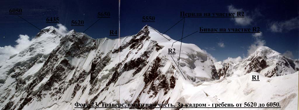
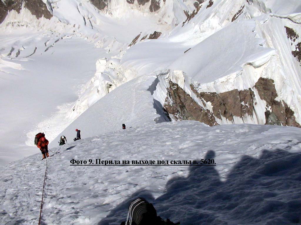
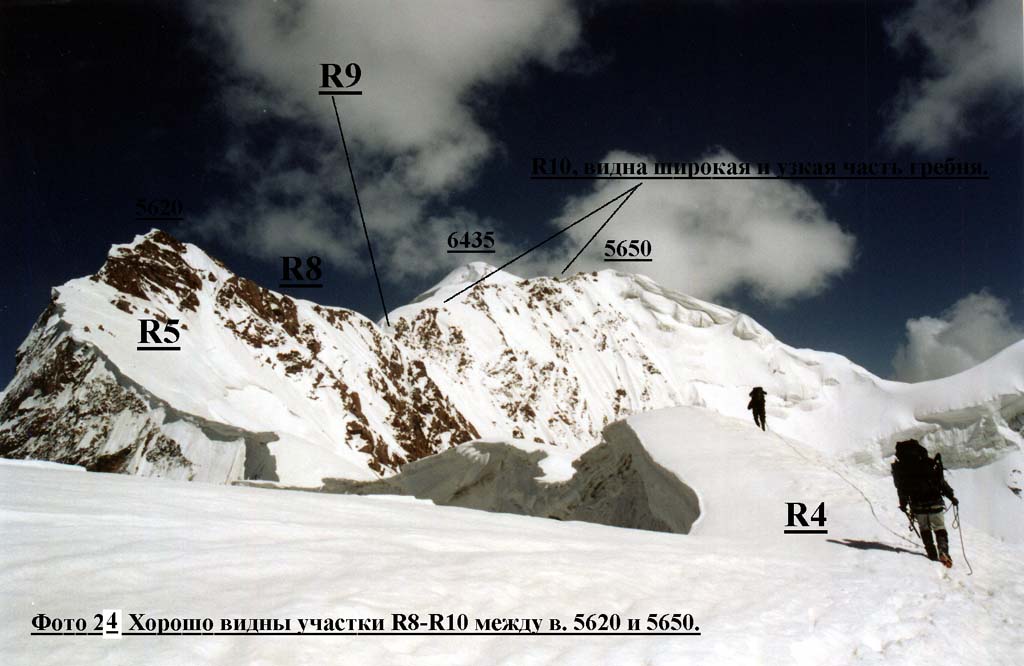
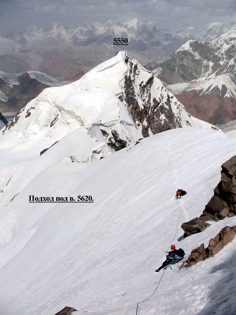
R4. Rather wide snow ridge with cornices under 5620 m peak's summit. Roped up, simultaneous belay (photo 6, 8, 23). R5. Snow-ice abrupt (up to 45 degrees) ridge with cornices. 3 pitches (140 m) under the rocks of 5620 peak, ice-screws. (photo 8, 9, 24).
R6. 90m traverse to the right on ice of 45-60 degrees, about 10 intermediate points on ice-screws for protection. (photo 8, 10, 25).
Rocky-snow wall, 80 m to the left - upwards to the summit of 5620 m peak. (photo 8, 11, 25). R8. Snow-ice ridge with cornices, 300 m, roped up, simultaneous belay. (photo 8, 12, 24, 26).
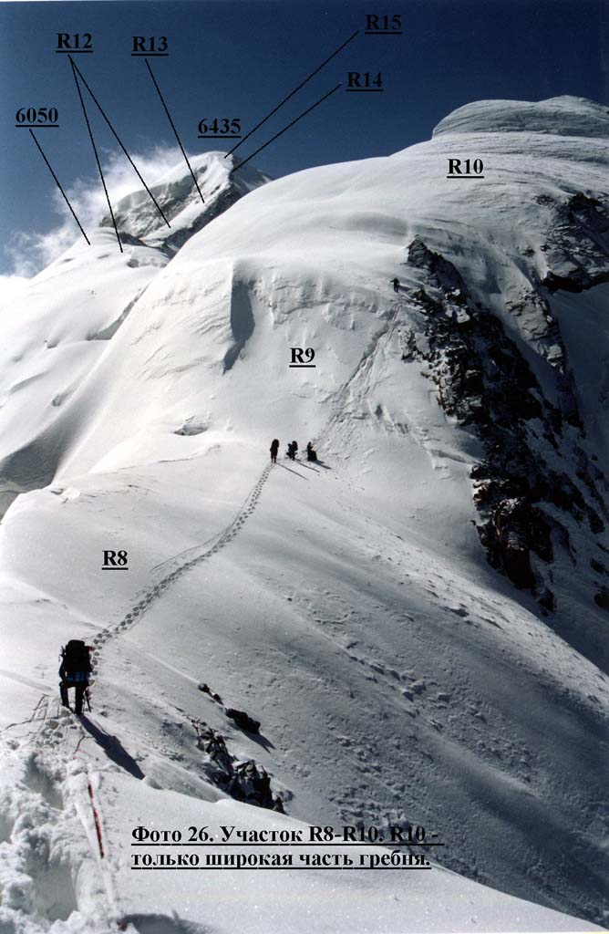
4-th day, 14.07 R9. Snow-ice wall up to 70 degrees, 25-30 m (fixed rope on an ice-axe and an ice-screw). (photo 8, 26). R10. Narrow rocky-snow ridge with cornices over 5650 m peak. Fixed rope, simultaneous belay, about 2km long. (photo 8, 13, 24, 26, 27).
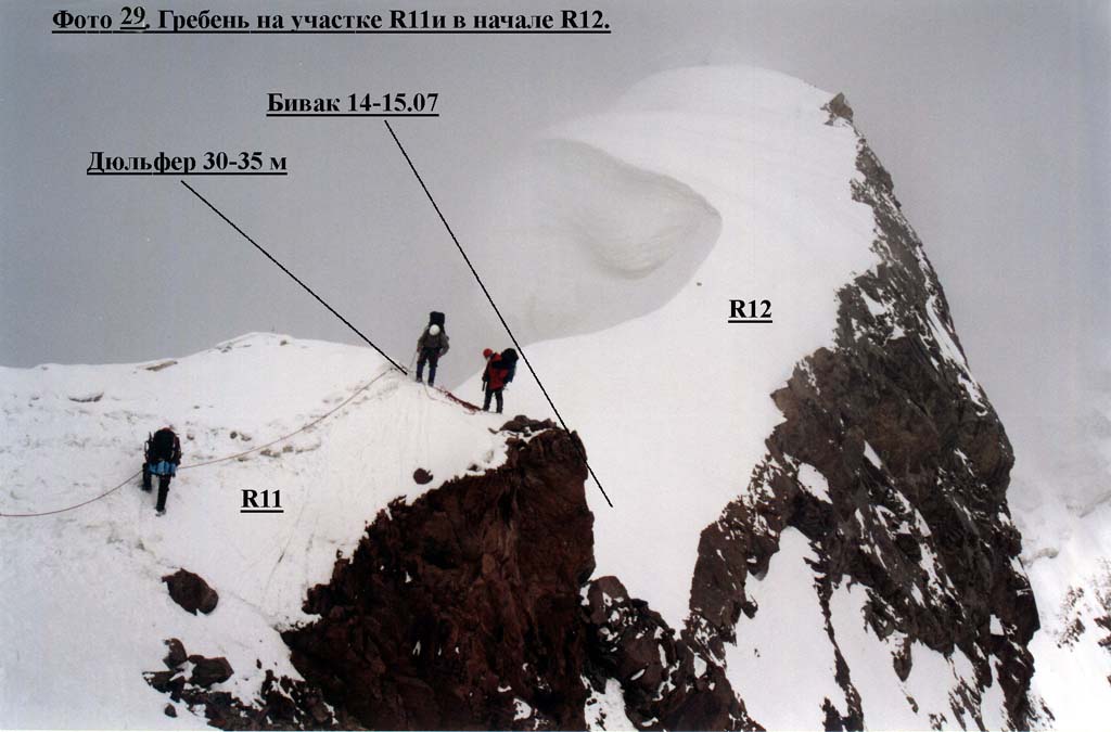
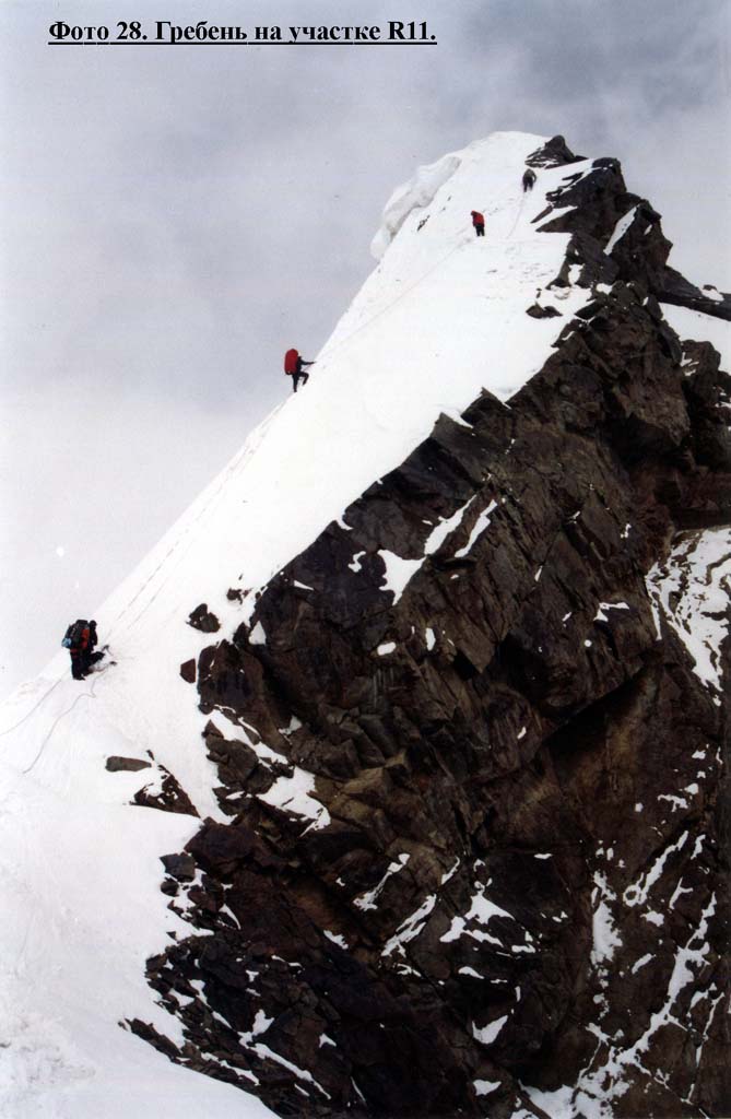
Technically complex ice-rocky ridge, fixed rope, 30 m ice rise, then traverse via 50 m of a narrow and sharp rocky ridge, ascent (ice) up 15-20 m and rappel 30-35 m, 45-50 degrees on the next lowering.(photo 14, 28, 29).
5-th day (forced rest)
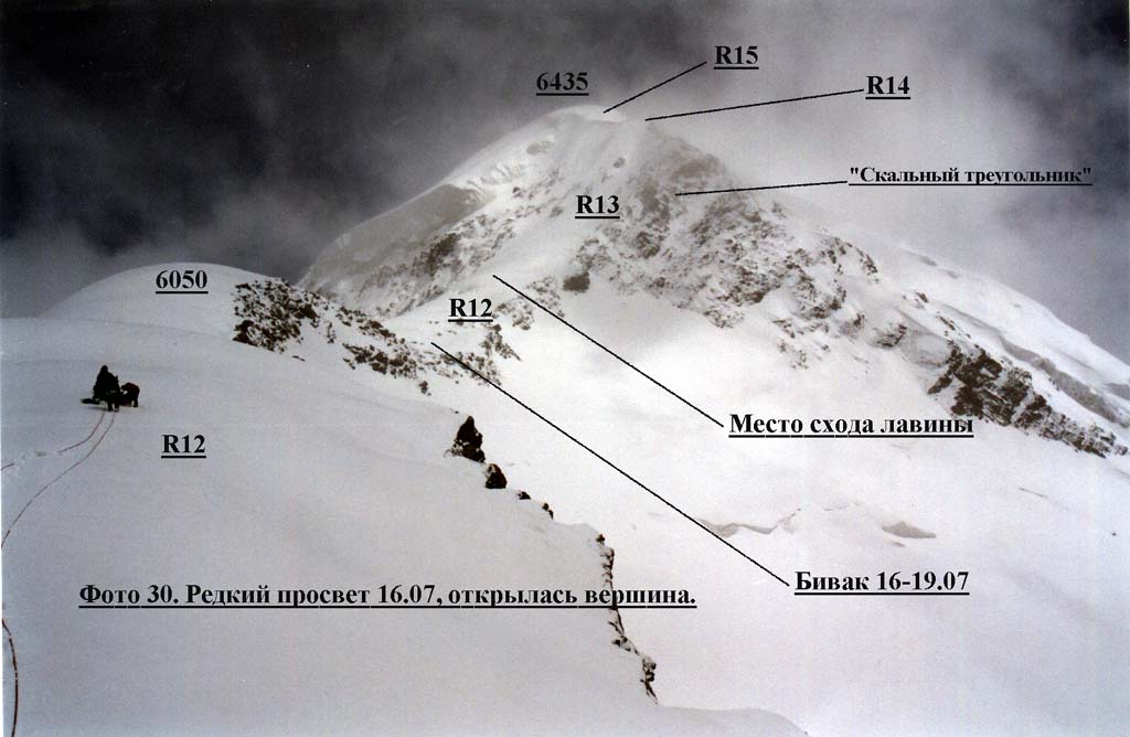
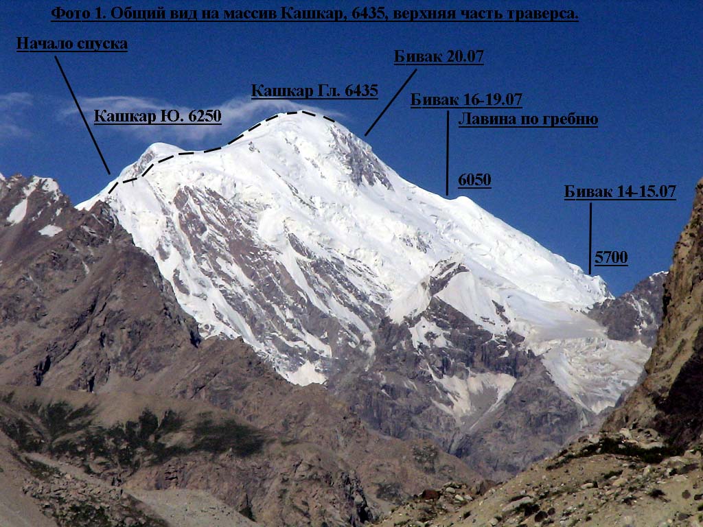
6-th day, 16.07 R12. Rather wide (up to 5-6 m width) snow-rocky ridge about 2 km long or more, roped up, basically simultaneous belay, fixed rope from time to time (heavy breaking trail). Up to approximately 6100-6200m. (photo 1, 7, 29, 30). Photo 29. The ridge at R11 and in beginning R12
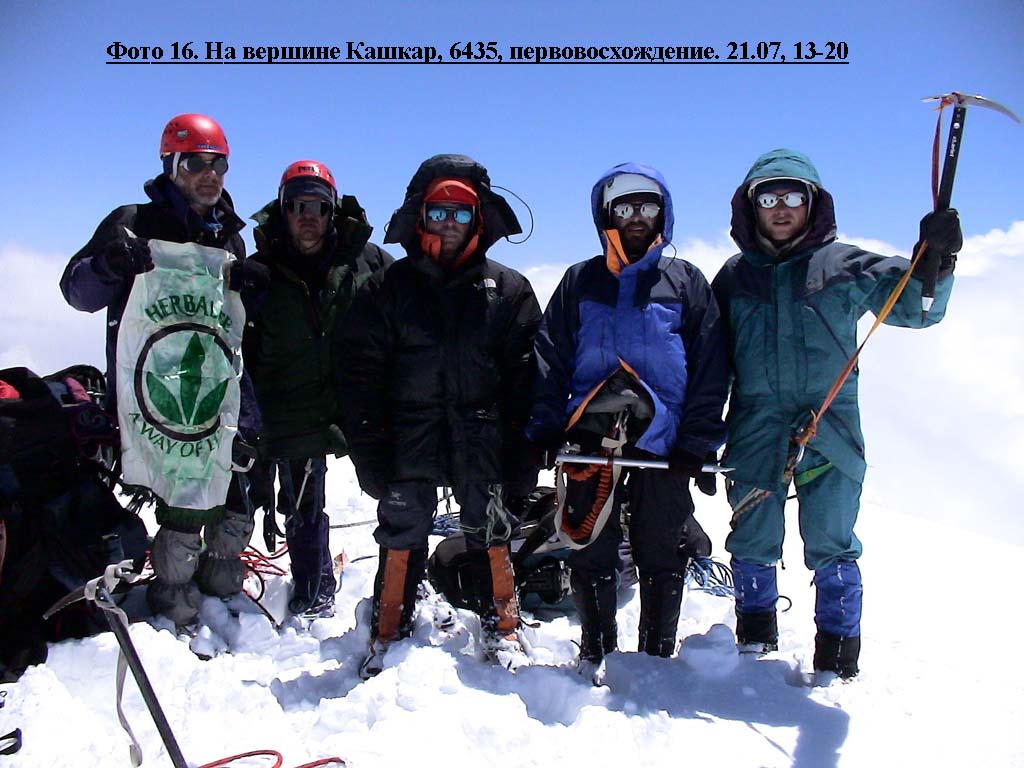
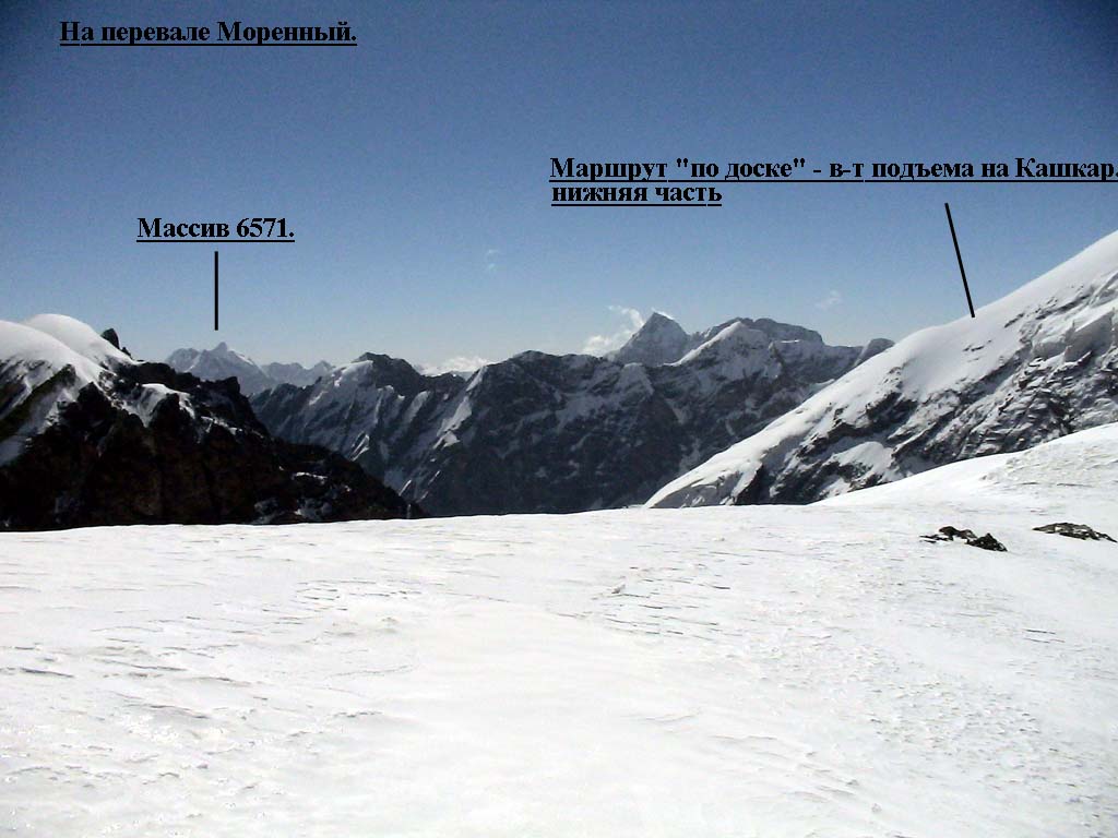
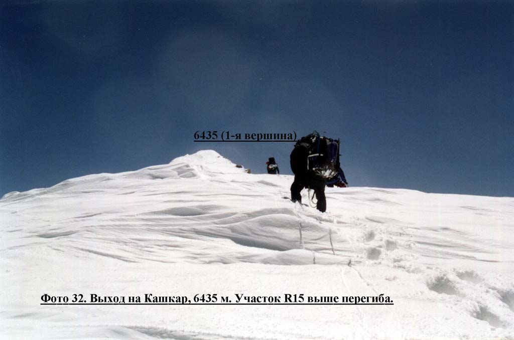
10-th day, 20.07 R13. Snow-ice slope of steepness up to 50 degrees to the left above the rocky triangle. Fixed rope using ice-axes and ice-screws, 150 m. (photo 7, 8, 26, 30). R14. Narrow flat rocky ridge with 1,5-2 m walls, ice and snow sites, using ledges and ice-screws to organize pitches. Only 130 m, 3 pitches, under the summit dome. (photo 7, 8, 26, 30). 11-th day, 21.07 R15. Summit dome up to 30 degrees, roped up, heavy breaking trail, sometimes without a backpack, 200 m - up to the bend, 250-300 m - up to sharp summit, steepness up to 10 degrees, deep snow. Further a snow ridge with small lowering between the sharp top and the dome downturn, 100-150 m. (photo 15, 30, 32, 33).
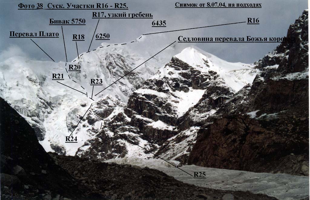
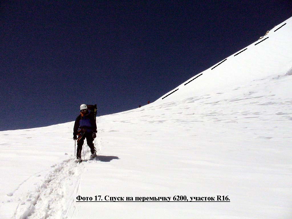
(photo 1, 17, 18, 38).
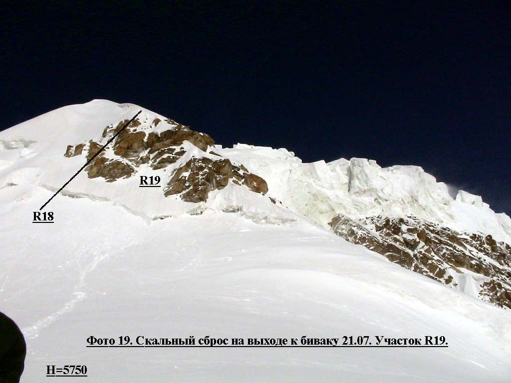
(photo 38) R18. Abrupt snow ridge (up
to 50 degrees). Simultaneous belay, 200-300 m.
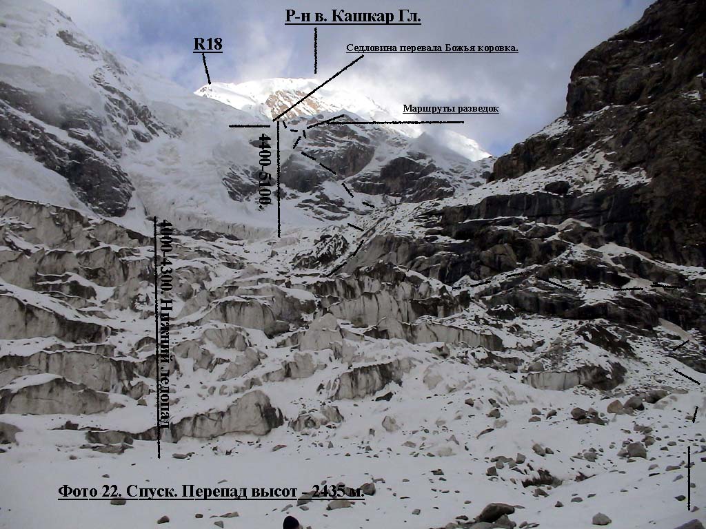
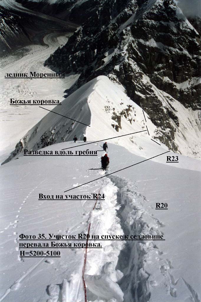
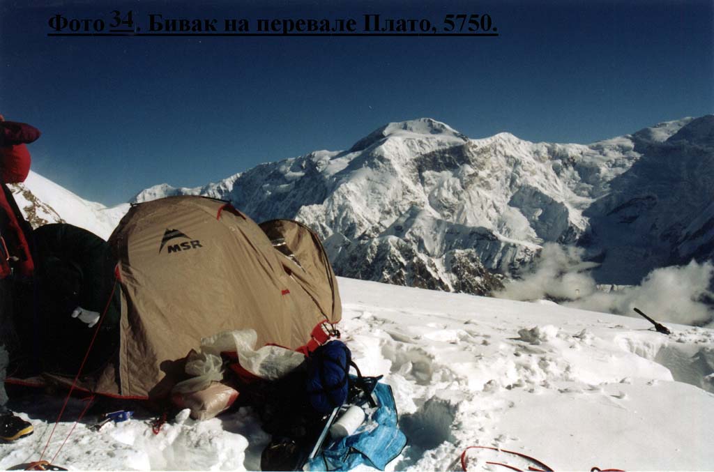
12-th day. 22.07. R20. Snow-ice avalanche dangerous slope of 30-40 degrees, 500-600 m (altitude difference 400 m), then a narrow ridge to Ladybird pass. Descent down falling water gradient. We moved one snow slab. (photo 20, 22, 35, 38). R21. Snow-ice slope leading
from the pass, cut with a bergschrund; 40-45 degrees, 80 m (two pitches).
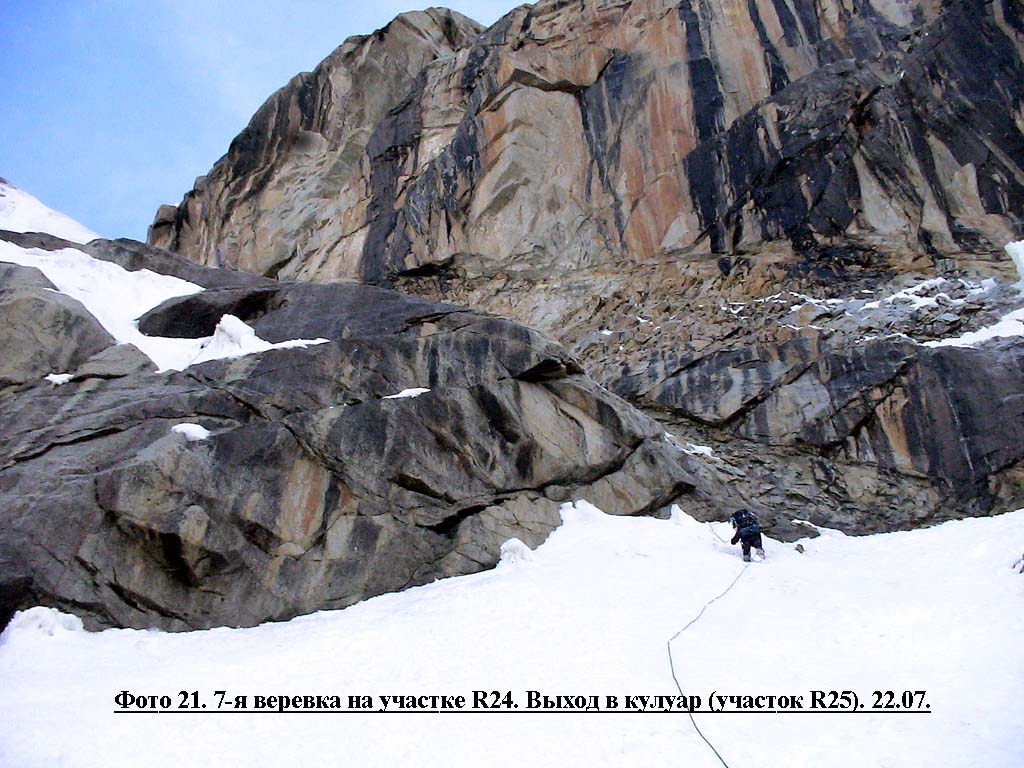
R25. Wide ice-rocky couloir of 30-50 degrees, 600-700 m, filled with lumps of collapsed avalanches. Roped up, simultaneous belay. (photo 21, 22, 38). R26. Snow covered glacier, then ice-falls, altitude difference 300 m, roped up. The route was got over. (photo 22)
Team's tactics Actually the north ridge appeared a little bit more difficult than we expected based on available photos.
For this moment it was clear only, that the summit already was close, but we couldn't see it because of bad visibility. We hard saved fuel (200 g a day), cooked and full-value ate once a day, limited water drinking. Additional water was extracted in flasks - we filled them with snow and heated in sleeping bags. It is necessary to tell, that similar measures did not lead to improvement of our common health state at all, and fatty body stocks began to thaw literally on eyes. We could felt full autonomy of our expedition: there was nobody to communicate on a portable radio set and ask to bring fuel and food. Everything, that we could do: to call satellite phone and inform about our "good things". For this reason all these days I did not get phone at all. Well, I had a serious hope that bad weather nevertheless holds more than10 days. And only after we summited I called to Moscow and informed that we finally got to the top and would inform details from base camp in two days.
This descent was not easier than our ascent; it simply was shorter and faster. But finally we reduced altitude on 2435m for two days. And 23.07, sheltered in a pocket of Ladybird glacier under a huge hanging stone from a torrential rain, we, at last, had dinner. For the first time for 10 days… So the weather completely broke our tactical plans. This first ascent turned out with all surprises that mountains are capable of.
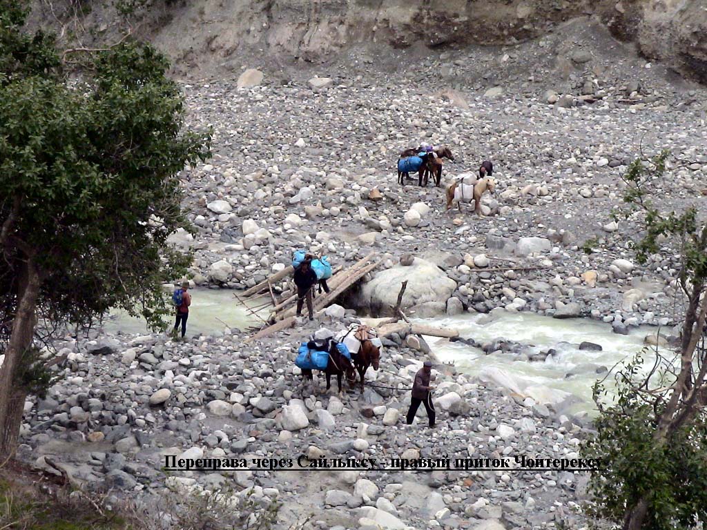
Ascent description Approach. From the base camp on a feebly marked track of the right-bank pocket of Chonteren glacier we moved up to the first right glacier inflow. Straight behind it we began ascending a conglomerate upwards morainic ridge, after it -a grassy pocket. On the ridge we went to the second right inflow - the river from Uyutny glacier. It was raining all the time. On a moraine near the creek we set a camp.
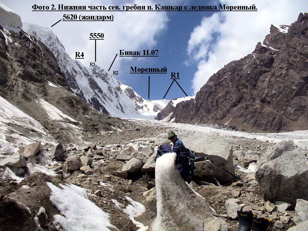
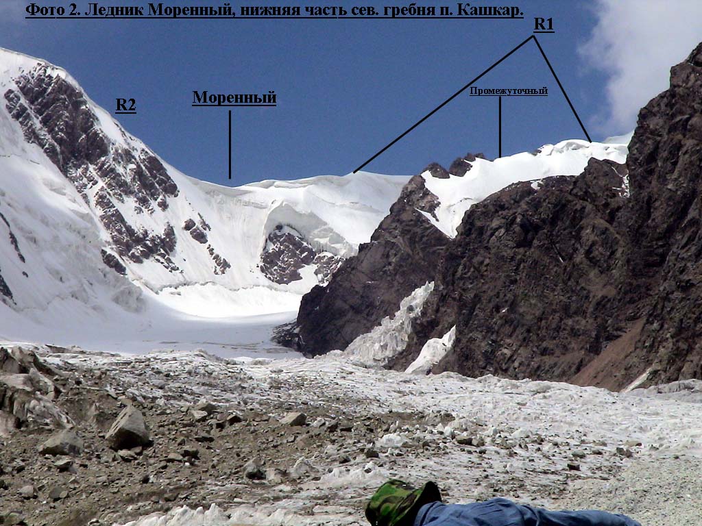
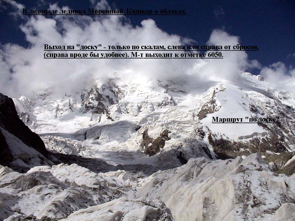
In the morning we forded the creek and went forward little still on the moraine pocket, then we descended on a Ladybird glacier body and crossed it; descended again in the right rantcluft. Two years ago we moved along the glacier, and now decided to look a pass here. As the result we managed to pass but it was longer and dangerous in places. So it would be better to go on the glacier. By the evening we reached a grassy pocket where we already set a camp in 2002. After spending the night we left early in the morning. Ilya felt better after food poisoning, everything already was normalized, our rate increased. Soon we were involved in an ice-fall. All that we especially remembered was heavy breaking trail when we crossed this ice-fall in 2002. Now it was open, and appeared not so simple. We spent practically a half of day crossing it. Till the afternoon we went an undiscovered part of the glacier (photo 2). It was more convenient to go center, but there were huge faults right before under the pass entry and such a flat simple ice-fall again. We went up winding route alternately belaying on the bridges, and by 20-00 we appeared in the upper corrie. We spent the night on a talus on the left flank.
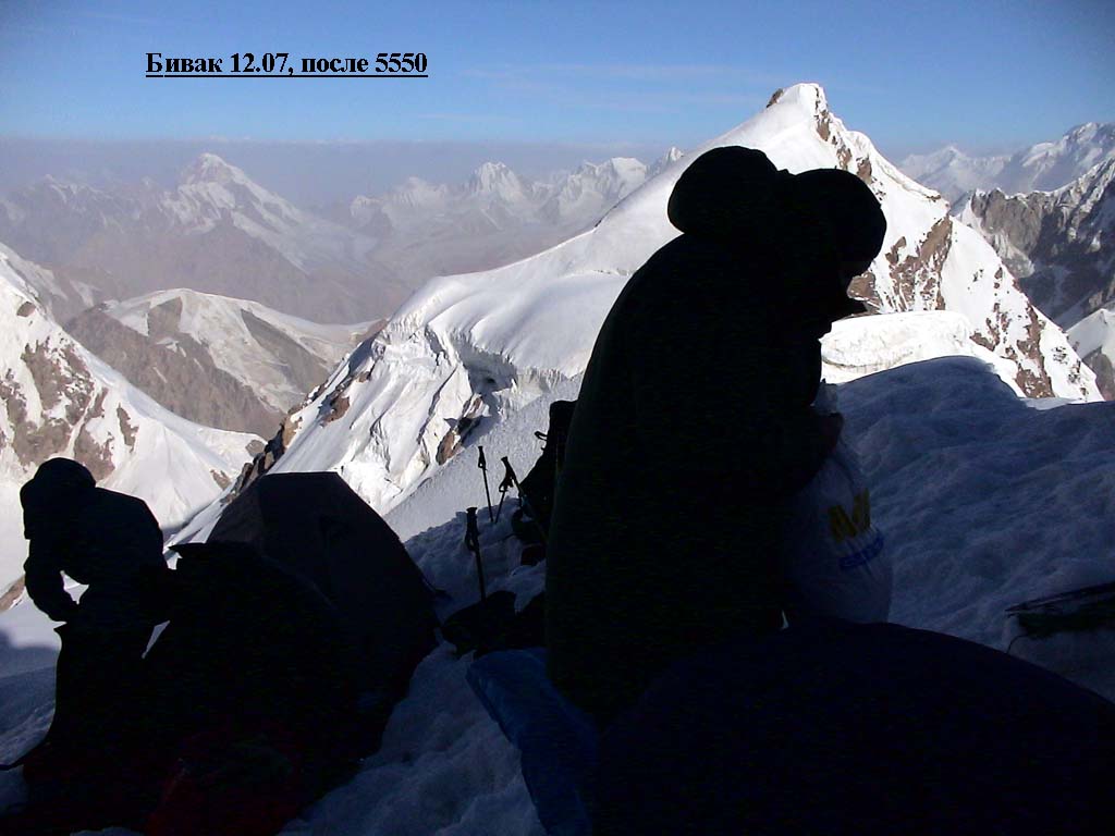
2-nd day, 12.07.2004. As we got to sleep late we woke up only at 11.30. Then we climbed 50 m roped up, farther: 250 m of fixed rope up again to the 5550m peak summit (photo 23). Then we made 2,5 pitches descending over a cornice to the ridge continuation (photo 5, 6), then again moved roped up and set a camp on a cornice not so far from a 5620 peak's rocky gendarme. It probably was the crux of the route. 7 working hours.
4-th day, 14.07.2004. We left at 10-45. We fixed up the rope over the wall using ice-screws and ice-axes (photo 26) In the morning the sun appeared for a short moment, waved his rays and disappeared. Snowfall, a wind began, visibility was 20-100 m. By 13.00 we reached 5650 peak (photo 8, 24). We had a bite at zero visibility there. Then sometimes the sky was cleared up again a piece 20-100 m of a ridge became visible. We went until rested against an ice wall - more likely a slope where fixed the rope about 30 m. From below this part of the ridge was not read at all. It turned to the right to the top 5650 and was very narrow, rocky-snow, with failures upwards - downwards (photo 27). And then it sharply turned to the left, practically to the east, and after a little the wall the ridge became absolutely narrow and rocky with fine cornices (0,5-1m) hanging to the north. And to the right there was a wall of 70 degrees passing in a plumb. But the ridge itself was flat (photo 14).
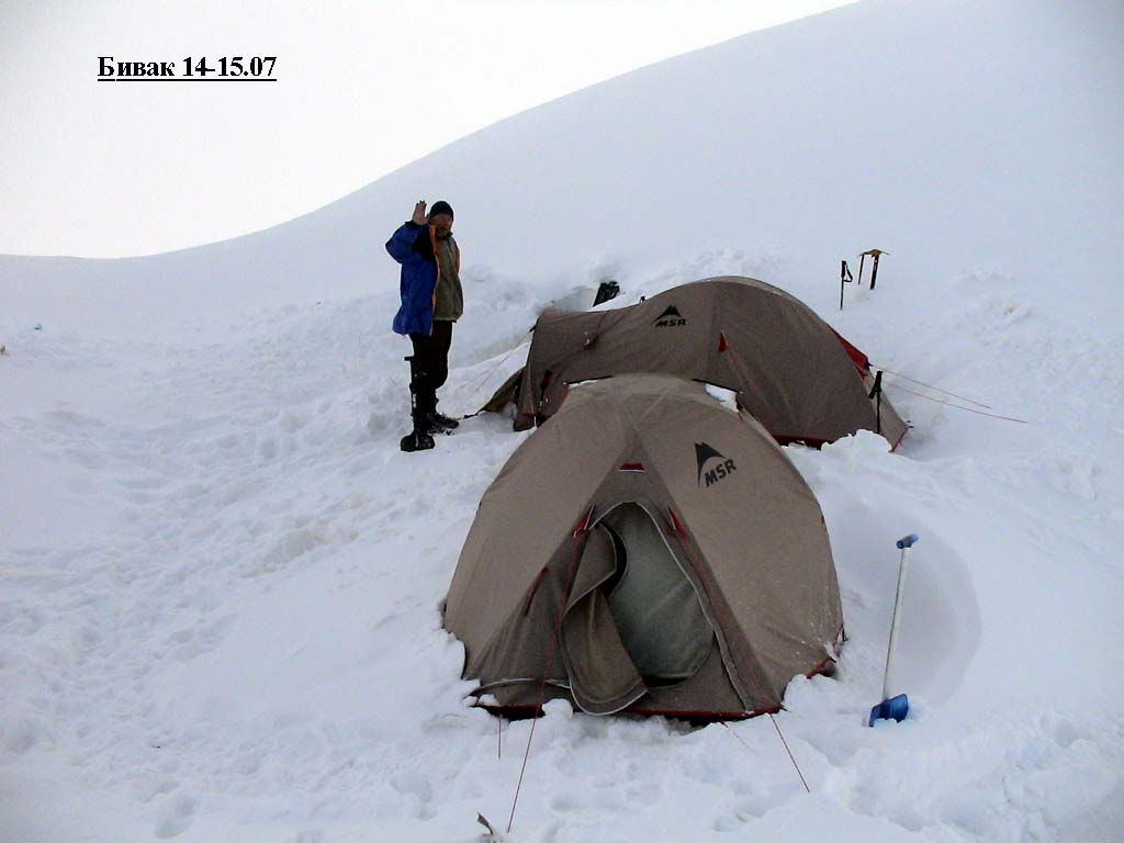
5-th day, 15.07.2004. There was a snowfall, a strong wind and zero visibility. We had to have a forced rest and sit in tents … 6-th day, 16.07.2004. A snow, a strong wind, visibility up to 100 m. Rather wide snow-ice ridge (photo 29, 30). At such visibility it was difficult to understand our location. It seemed we should already be under the top for a long time, but we were far from it. On the ninth hour of our way we got out at 6050m. (photo 1, 7, 30) - in the next short gleam we even saw Kashkar’s slopes. At last we reached under the top. And climbed the ridge where fixed the rope on abrupt sites. In total passed about 2 kilometers. 7-9-th day, 17-19.07.2004. A snow, a strong wind, visibility zero. We had a rest again. Every day we had to dig out our backpacks from 1-2 m depth. And the tents we dug out too… 18.07 an avalanche collapsed dawn on the ridge. It demolished one tent, covered 3 guys, one of them was seriously buried. We got them in 15 minutes, common time of excavation and searching lost things took 5 hours. We found practically everything (the main thing - stoves!!), our losses - one shovel, ski poles. The tent was broken, but we managed to fix it. In the morning of 19-th gleams appeared in the sky, but a wind was very strong. When we already were going to leave in the afternoon snowfall began covering with new force …
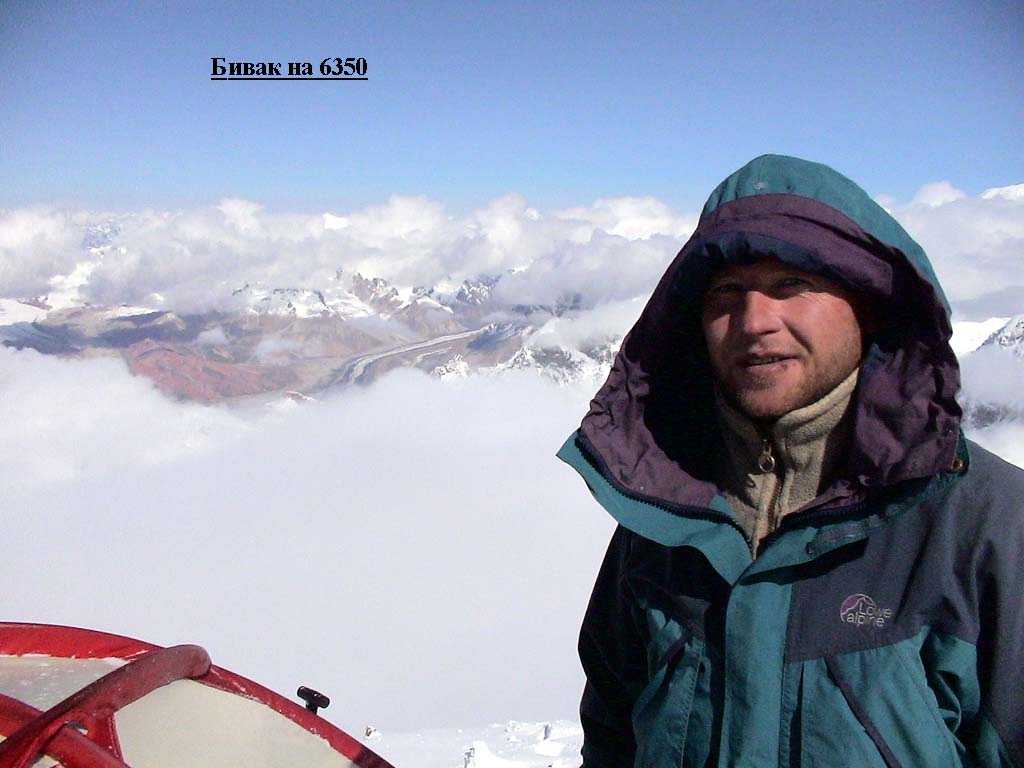
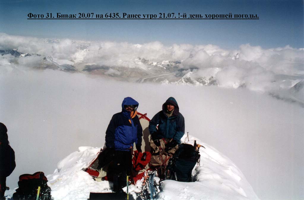
We left in the afternoon. It was very cold. And we could hardly move. We made 3 pitches along a rocky triangle of the top on a snow-ice slope (photo 7, 8, 30), and 3 pitches more - on a flat but narrow rocky ridge. For eight and a bit more hours we got out only under a dome of the summit, somewhere at 6350 m. Visibility disappeared, the same we could say about our forces. Again we set a camp (photo 31).
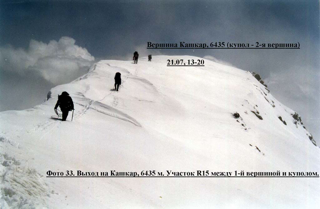
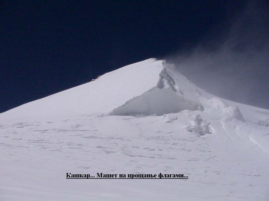
Further we moved roped up for four hours. First there was a simple ridge between sharp small buttress and a big dome (photo 33) I do not know what of them to consider correctly as the summit: their altitude were identical, and there was 150-200 meters between them.
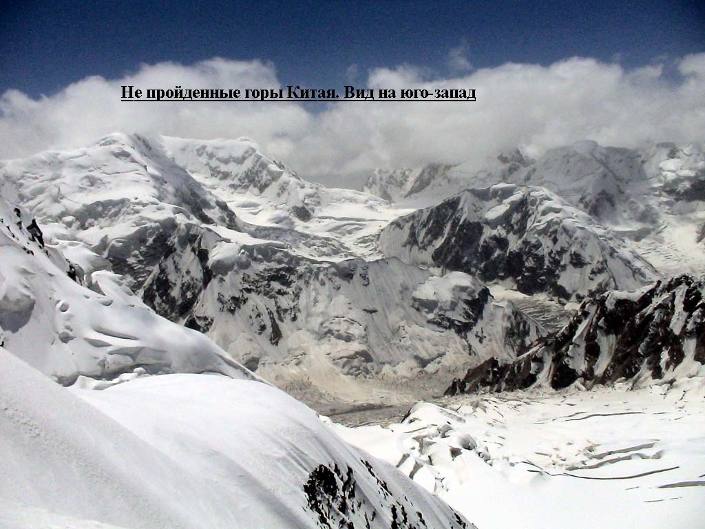
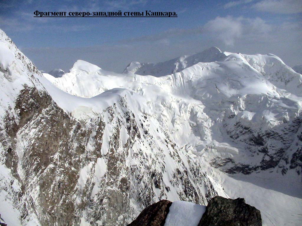
Then we went the ridge up to the cofferdam 6200m between Southern and Main Kashkar. (Southern Kashkar is quite independent summit of 6250-6300m. If we had had time we would have summit it). Further we went to the left, on the east, aside prospective descent to Plateau pass and rested against huge ice faults. We had to find farther way. There was not the exit to the left because of a wall; there was a ridge to the right, but with increasing steepness, therefore only a small site of it was visible (photo 18). Soon it became impossible to move in snowshoes: the steepness was already about 40 degrees, and further increased. We put on crampons and moved further belaying in places. Short faults with cracks were quite passable if you were roped up there. Then we left on a narrow and sharp ridge with cornices (photo 38) from where moved further about 200 meters with alternate belay, basically fixed on an ice-axe. The abrupt snow-ice slope to the right along rocks on which it was possible to descend on the plateau was seen, but we had to fix about 400 meters. At last we passed the ridge bend. Further it was more abruptly, but the ridge extended, we went roped up again. As the ridge branched, we chose the branch that deduced us on rocky fault (photo 19). Having made only one pitch from there we already appeared on the ridge of Plateau pass. But we could hardly make this rappelling: obviously we were exhausted up to the limits. We descended more than 2 hours, almost up to the darkness.
12-th day, 22.07.2004. Weather was good, a strong fair wind blew. There was a 400 m (altitude difference) snow avalanche dangerous slope of 30-40 degrees ahead and it was impossible to bypass it: only via 1000m (altitude difference too) icefall of Plateau pass. But I did not think that the conditions were better there. (photo 20). We could see traces of collapsed snow slabs. And we dared and started to descend hoping for luck. We descended about 100 meters when moved a slab - it was the first and unique and we had luck. It was not friable snow, the whole mass of snow inspired respect.
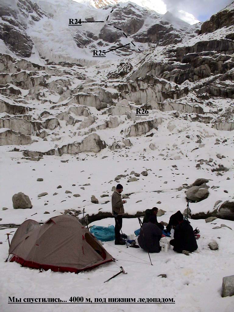
So, we had two variants of descent: via a couloir into uncertainty or to come back through Ladybird pass and to descend on Morenny glacier via the route that we passed in 2002. We chose a novelty and dived into the couloir (photo 22, 37, 38). Exits on rocky ledges where it was possible to spend the night were distinctly looked through there. After two abrupt reclipped 60 degrees rappel pitches we appeared on a flat rocky ledge. Then a route reco again and two reclipped rappels under hanging seracs - and again we reached a big convenient rocky ledge. Further the couloir passes in steep faults of 400 meters where it was impossible to pass through. But on rocks we found an ice layer that alleviated our life, and pass to the left, along a rocky wall (photo 21, 22, 38). Three rappels more - and we through a small fault were thrown out in rather wide rocky-ice couloir with similar system of rocky ledges filled up with lumps of collapsed avalanches (photo. 21, 38).
23.07.2004. I was on duty and could see the sun while cooked breakfast, but soon the sky was tightened, rain with snow began. We went the glacier average current ice-fall on right rantkluft that appeared unexpectedly complicated because of stone-fall danger especial in rain. We spent a half of a day to pass it. For the first time for 10 days we had dinner in a grassy pocket, having taken shelter from the rain under a big stone. At 20-00 we got to the base camp.
Ascent Analysis Our team was no so strong to realize everything that we had planned. We wasted a lot of time to our regret. But a problem of good weather was more urgent there. But we did not bail and turn back. In spite of anything. Could we be able to do our best? Yes. I think, about the things that forced us to go forward - the gone boundary (back way seemed longer) or desire to take it more? In fact there were variants of deviation. During some moment a sensation of unreality of the event appeared. The sensation, that mountains just did not want to let us go. And when we got out at 6350, they let us at last and gave us only two days to get out choosing the correct decision about descent line… Technically all the traverse was 4B-graded, but its extent, altitude, and, probably, full autonomy of this ascent we can consider as 5Ŕ. But we were exhausted as if we did a good "six"-graded route.
To our regret the described events compelled us to turn back the expedition - losses of time, illness, freezing injury unseated 4 persons from six. So, a result of our ascent and expedition as well is the first ascent on a beautiful isolated peak Kashkar, 6435 m. It is the first "Russian" "6-thousand" mountain in Chinese Tien-Shan It is not a great achievement but it not so bad too. And peak of Voennykh Topographers will wait. For me or someone else. And there are about twenty unclimbed "6-thousand" mountains there. And they are not simple to be climbed. And two towering faces are worthy to climb there - on Pobeda Peak and Voennykh Topographers. But and Kashkar peak, northwest face, seems attractive to climbers. One notice: this area is too severe from time to time … Portfolio
|
|||||||||||||||||||||||||||||||||||||||||||||||||||||||||||||
| © 1999-2007 Mountain.RU Mail to: info@mountain.ru |
|