|
Author: Maxim Foigel, Krasnodar
Peak of Lenin
3. Route to top of the Peak of Lenin via the Peak Razdelnaya (№3)
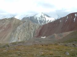
Route to the pass of Travelers.
|
The route starts from the "Onion field"( 3800 m). Along a good path you climb up to the pass of Travelers ( 4150 m).
Further you descent to the glacier of Lenin and go along the path along the glacier, then come to the glacier in its middle stream. Up to the coming to the body of the glacier, the path is rather good. Sometimes it can become a problem to cross the stream, flowing from under the glacier. Along the glacier you go not coming for about 1000 m to a steep rise of the glacier (the bottom of the summit itself), then turn to the right (according to your direction of walking) moraine and along it come to the place of the first altitude camp ( 4400 m), near the slopes of the spur of the Peak of 30 th anniversary of UzSSR ( 5688 m).
All the way long from the &ldquoOnion field&rdquo takes 4-6 hours. In high season way along the glacier is marked. On this strip you can use horses for carrying your cargos.
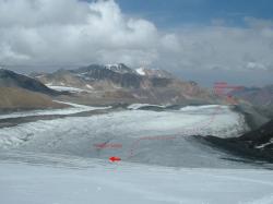
Way to the camp 1 ( 4400 m) along the glacier of Lenin
|
|
|
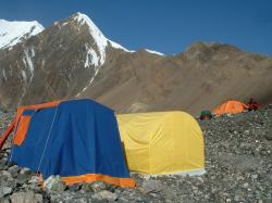
Camp 1 ( 4400 m) |
|
|
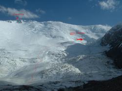
Way to the camp 2 ( 5200 m) |
From the camp 1 further way leads you up along the glacier of Lenin. Way up goes up between two icefalls.
The direction of going &ndash almost straight upwards. From about the altitude 5000 the rise become less steeper and the path turns to the right in the direction of the Peak Razdelnaya ( 6148 m).
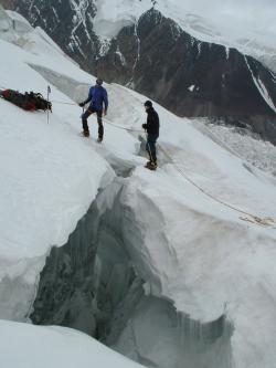
On the way to
the camp 2 |
The last strip of the way is traverse to the place of the second camp, or simply to the &ldquopan&rdquo ( 5200 m), that is located near the slopes of the Peak of 30 th anniversary of UzSSR ( 5688 m).
If the state of snow is special, way from the camp 1 to the camp 2 can be dangerous for avalanches. There are many closed cracks, in some years the glacier is strongly torn.
Way from C1 to C2 takes about 4-6 hours.
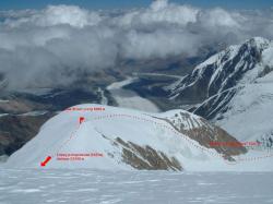
Way to the camp 3 (6100 m) |
From the camp 2 go straight upwards along the steep slope of the Peak of 30 th anniversary of UzSSR ( 5688 m), then you come to the edge and climb along it to the Peak Razdelnaya ( 6148 m). Further you descent to the saddle of the Western edge of the Peak of Lenin. Camp 3 is located on the altitude 6100 m. Way to C3 from C2 takes 3-5 hours.
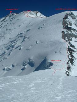
Way to the top
|
From C3 you climb along the western edge of the Peak of Lenin to the wide shoulder (6400). If it is necessary, you can make an extra fourth camp there. Further you go up for about 200 m along narrow steep edge (&ldquoknife&rdquo) and then along slightly-sloping strongly destroyed covered with snow rocky edge come to the apical cupola of the Peak.
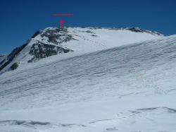
Apical cupola
|
Further the shortest way to the top lies along the left side of the apical cupola. The apical cupola presents a slightly-sloping snow slope with outcrops of destroyed rocks. When the weather is bad, you can come across difficulties with orientation.
The most dangerous place on this strip is 200 meters long steep snow slope &ndash &ldquoknife&rdquo.
Climb from the C3 to the top of the Peak of Lenin ( 7127 m) takes 6-8 hours.
Time in this article is given, taking into account alpinists that haven&rsquot high-altitude experience but are physically prepared for such a work. As usual, the descent takes half of time you spend on your way up.
4. Recommendations.
4.1. About acclimatizing.
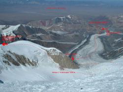
General photo of the route, view from
the Eastern edge of the Peak of Lenin.
|
There can&rsquot be an ideal scheme of getting acclimatizing for high-altitude ascents. There always are circumstances, influencing on the regime of the ascent, that are difficult to take into consideration: for example, personal grounding or weather during the ascent. Below there are given several variants of schedule of the ascent to the Peak of Lenin.
As nowadays one of the most popular and often visited routes to the Peak of Lenin is route along the Western edge via the Peak Razdelnaya (), the examples are attached to this route. But these schedules are only examples and you can not consider them to be the only correct.
Ideally, every high-altitude ascent is preceded by the cycle of trainings, including ascent to the peak, that is lower than wishful summit. If it is the question of the summit higher than 7000 m, it is desirable to have an experience of climbing to the summit at least 5000 meters high.
Variant № 1.
1 st day. &ldquoOnion field&rdquo, altitude 3800 m. It is the day of coming up to the BC.
2 nd day. Devote this day to preparing for forthcoming ascent. It will be the first day of acclimatizing for your organism, don&rsquot speed up occurrences.
3 rd day. Ascent to on of the nearest peaks up to the altitude about 5000 m and descent to the BC at the same day.
4 th day. Way to the Camp 1 ( 4400 m).
5 th day. Way to the Camp 2 ( 5200 m).
6 th day. Ascent to the Peak Razdelnaya ( 6148 m). You can bring some equipment and provision to the Camp 3. Descent to the Camp 1 should be made at the same day.
7 th day. Day-off in the Camp 1 ( 4400 m).
8 th day. Way to the Camp 2 ( 5200 m).
9 th day. Way to the Camp 3 ( 6100 m).
10 th day. Ascent to the top and descent to the Camp 3.
11 th day. Descent to the Camp 1 ( 4400 m).
12 th day. Descent to the BC ( 3800 m).
Pay attention, please that in the plan there are no reserve day for waiting for the weather. You should plan this possibility taking into account you personal time and tickets.
Variant № 3.
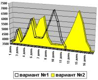
Scheme. Schedule of altitudes.
|
1 st day. &ldquoOnion field&rdquo, altitude 3800 m. It is the day of coming up to the BC.
2 nd day. Devote this day to preparing for forthcoming ascent. It will be the first day of acclimatizing for your organism, don&rsquot speed up occurrences.
3 rd day. Ascent to on of the nearest peaks up to the altitude about 5000 m and descent to the BC at the same day.
4 th day. Way to the Camp 1 ( 4400 m).
5 th day. Way to the Camp 2 ( 5200 m).
6 th day. Acclimatizing ascent to the Peak Razdelnaya ( 6148 m) and descent to the Camp 2 ( 5200 m).
7 th day. Way to the Camp 3 ( 6100 m).
8 th day. Acclimatizing climb up to the altitude 6400 m, to the shoulder of the Western edge (place of possible making camp 4). Descent to the Camp 1 ( 4400 m).
9 th day. Descent to the BC ( 3800 m).
10 th day. Day-off ( 3800 m).
11 th day. Day-off ( 3800 m).
12 th day. Way to the Camp 1 ( 4400 m).
13 th day. Way to the Camp 2 ( 5200 m).
14 th day. Way to the Camp 3 ( 6100 m).
15 th day. Ascent to the top and descent to the Camp 3.
16 th day. Descent to the Camp 1 ( 4400 m).
17 th day. Descent to the BC ( 3800 m).
Pay attention, please that in the plan there also are no reserve day for waiting for the weather. This variant requires more time, but acclimatizing is being got more effectively.
|


 При вводе Логина и Пароля,


 При вводе Логина и Пароля,

